Vancouver is covered by a blanket of clouds throughout most of the year, but on a clear day, students can see two mountains, Mount Hood and Mount St. Helens, located on the quad from campus. While both make for a beautiful view at dusk or dawn, eerily enough these mountains are also known to be active volcanoes.
Volcanoes may seem terrifying since they are known to cause massive amounts of damage. However, those living in Vancouver might not have to worry about extreme outcomes if a nearby eruption takes place. John Bishop, WSU Vancouver professor of the department of biological sciences, is currently conducting ecological research on Mount St. Helens, the closest and most active volcano visible from campus.
“I can tell you the risk of Vancouver being impacted by an eruption from the big stratovolcanoes is extremely low. … Other areas in our region are more at risk,” Bishop said.
The United States Geological Survey’s website (USGS) defines stratovolcanoes, similar to the ones on campus, as “steep, conical volcanoes built by the eruption of viscous lava flows, tephra, and pyroclastic flows.” Additionally, the USGS operates locally in the Cascades Volcano Observatory located in Vancouver. Nearly two years after the catastrophic eruption of Mount St. Helens in 1980, CVO was established in 1982 to study the volcano’s activity. Geologist at CVO, Elizabeth Westby, says the observatory is also used to monitor activity from the Cascade volcano range across Idaho, Oregon and Washington. She explains the observatory uses instruments such as seismometers to record any changes of activity in ground motion to possibly detect if an earthquake or volcano is about to occur.
“You are more likely to experience an earthquake than a volcanic eruption. The Vancouver area is more likely to shake, not bake. Still, there is a lot to learn about living in the shadow of volcanoes,” Westby said. “We have 20 monitoring stations on Mount St. Helens, and that’s a lot. We don’t have as many on the other ones, but Mount St. Helens is the youngest, the most active and the most likely to erupt again.”
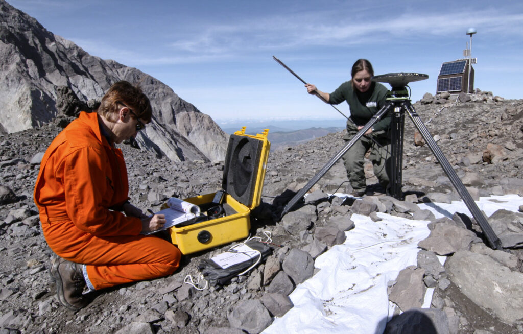
In the field, CVO employees utilize helicopters to set up different stations near the volcanoes to monitor activity. CVO has also implemented a GPS system, and seismic tilt stations, to observe the surface of each volcano in response to physical changes caused by magma pushing up from below Earth’s surface.
“We have found that you need to have a lot of different stations and different kinds of data coming in because it is not just earthquakes, not just gases or deformation, you really have to take a look at all of these things to figure out what might be going on and then what might happen next,” Westby said. “That is why it is important to have stations because we are developing what is normal for Mount St. Helens, or Mount Rainier or Mount Hood. When things change, we are on top of it, then we feel like we are better prepared.”
In the rare case of an eruption, Vancouver is likely not subjected to a flowing path of burning hot lava, but would instead be at risk of being buried by giant mudflows, which Westby calls lahars, or big blankets of ash.

(Photo courtesy of Elizabeth Westby)
“If there was, say, an ash eruption at Mount Hood, the ash will go where the wind is blowing. We know from Mount St. Helens in 1980, when that erupted, the prevailing wind direction was to the east. So on May 18, 1980, you had all these people in Portland that are going ‘wow, look at this amazing eruption,’ and then people east, like in Yakima and eastern Washington are the ones that got ash,” Westby said.
Westby explains that driving would likely be hazardous after a volcanic eruption due to ash and rain making roadways slippery, and disrupt visibility, which occurred after the Mount St. Helens eruption of 1980. Additionally, going outdoors without a mask, amidst the ash fall, was unwise after the eruption due to harmful effects of breathing in particles.
“The ash triggered stampedes for face masks, car air filters and food staples, as noted in the local newspaper articles. … So that is kind of what we really have to worry about in Vancouver. There is the potential for ash fall, in which case, the thing to do would be to shelter in place until the ash stops falling, because you do not want to drive in it,” Westby said.
Although it is impossible to predict with absolute certainty when a volcano will erupt, USGS released an updated Volcanic Threat Assessment in 2018 that examined the potential threat and hazardous factors of each volcano. Mount St. Helens, Mount Hood and Mount Rainier are identified as having very high threat potential, and Mount Adams is identified as having only a high threat potential.
“The study was done to take a look at the volcanoes and their eruptive histories, what they have done in the past and what they are capable of doing. Are they explosive? Are they just small lava flows? So, they are taking a look at the hazards associated with the volcanoes and the people that are living nearby to come up with these threat categories,” Westby said. “Mount St. Helens is a very high threat volcano, so is Mount Rainier and Mount Hood. Not just in the way they erupt, but because so many people are living near volcanoes like Mount Hood. … So the idea is to categorize them based on not just what they can do, but the people that can be impacted nearby.”
If a volcano near Vancouver did erupt, CVO would notify the public through their social media pages and through Clark Regional Emergency Services, who would send updates about how to proceed given the situation. According to Westby, it is also a good idea to create an earthquake or volcano reaction plan, combined with the creation of an easily accessible survival pack. If a volcano erupts, be ready to shelter in place by stocking up on food, water, flashlights, batteries and other items that may come in handy if stores are closed due to heavy ash fall. Westby also recommends visiting USGS’s website for more information on volcanoes and live updates on seismic activity.
“[I’m] not trying to scare anyone about our volcanoes, I love volcanoes,” Westby said. “Just increasing awareness and encouraging personal preparedness for an eruption, or any of the many other hazards the planet is going to throw at us in the future.”